Showing posts with label Aerial View. Show all posts

Archive Photo : Titchfield Park

This aerial view of Titchfield Park was taken from the east, and shows the cricket field and tell-signs of the original formal gardens (now replaced by football pitches).

The cemetery can be seen in the bottom-light of the picture. Cherry Avenue and Laburnum Grove are to the left of the cemetery. Johnson Avenue and Broomhill Road can been seen on the far-left of the picture.

Park Drive can be seen running left-to-right, with Croft, Storth and Caddaw Avenues above.

The industrial units railway tracks (top-left) have been replaced by residential properties (Minstrel Close, Sheridan Way, Versaille Gardens, Vyella Gardens).

The main road in the top-left of the picture is Farleys Lane.

To compare with current satellite view, click here.

Archive Photo : Hucknall Airfield

This aerial view is taken from the west, and shows the runway and airfield buildings.

Bestwood Village can be seen in the top-right of the picture, in the far distance. To compare with current satellite images click here.

STORY TO TELL...? Please share it with us, using the "comments" box (below).

Archive Photo : Rolls Royce

This aerial view is taken from the south-west, and shows the airfield buildings.

The Shortwood Avenue/Farleys Lane area can be seen in the top of the picture. To compare with current satellite images click here.

STORY TO TELL...? Please share it with us, using the "comments" box (below).

Archive Photo : Long Hill Rise

Long Hill Rise (south side). To compare with recent satellite image, click here.

STORY TO TELL...? Please share it with us, using the "comments" box (below).

Archive Photo : Long Hill Rise

Long Hill Rise - northern side of the road is shown in upper-left, and southern side in bottom-right. To compare with recent satellite image, click here.

STORY TO TELL...? Please share it with us, using the "comments" box (below).

Archive Photo : Watnall Road and Long Hill Rise

Watnall Road running left-to-right, and Long Hill Rise in the top-right. To compare with recent satellite image, click here.

STORY TO TELL...? Please share it with us, using the "comments" box (below).

Archive Photo : Spring Street Schools

Aerial view of Spring Street Schools.

STORY TO TELL...? Please share it with us, using the "comments" box (below).

Archive Photo : Watnall Road/Central Station

Aerial photo, showing Central Station and its passenger footbridge adjacent to Watnall Road.

Former factory buildings in centre of picture still exist (see here).

Storth Avenue is clearly visible just beyond the factory, running left-to-right. Beyond Storth Avenue are the terraced houses of Byron Street and Orchard Street, which were replaced by modern housing in the 1960s (see Buildings Timeline).

Factory shown is Reynolds which manufactured ‘Renola’ brand underwear. (See Hucknall Textile Factories)

Archive Photo : Watnall Road/Storth Avenue/Caddaw Avenue

Aerial photo, looking east along Storth Avenue. Photo taken from Central Station area (rail line and bridge at bottom of picture), with Watnall Road running left-to-right.

Former factory buildings in centre of picture still exist (see here).

Branching off to right of Storth Avenue (top right of picture) is Caddaw Avenue.

Factory shown is Reynolds which manufactured ‘Renola’ brand underwear. (See Hucknall Textile Factories)

Archive Photo : Watnall Road Area

Aerial view, looking north along Watnall Road towards town centre. Photo taken above Central Station area (just visible at bottome-left of picture), and shows buildings which still exist (see here).

Factory shown is Reynolds which manufactured ‘Renola’ brand underwear. (See Hucknall Textile Factories)

On left is junction with Sandy Lane/Central Avenue. Storth Avenue's clearly visible just beyond the factory, running left-to-right.

Beyond Storth Avenue are the terraced houses of Byron Street and Orchard Street, which were replaced by modern housing in the 1960s (see Buildings Timeline).

Archive Photo : Town Centre

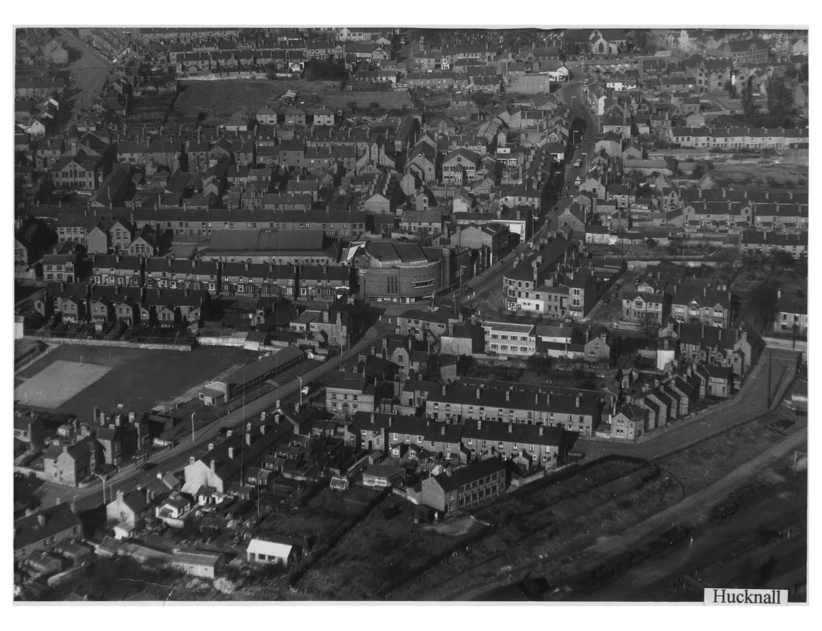
This aerial photo was taken from the south-east, looking towards Hucknall's town centre.

The Byron Cinema can clear be seen in the centre of the picture, standing at the crossroad of High Street (top-right), Portland Road (bottom-left), Duke Street (middle-left), and Station Road (middle-right).

The L-shaped road (mid-right) is Bolsover Street). In the bottom-right corner of the picture are railway trucks, indicating sidings from the main railway line. This area is now occupied by Corman's Factory Shop, some industrial units, and Tesco petrol station.

To the top of the picture, the parish church can just be seen. Market stalls are also visible.

STORY TO TELL...? Please share it with us, using the "comments" box (below).

Archive Photo : Hucknall Airfield

This aerial view is taken from the south, and shows the airfield buildings.

Watnall Road can be seen in the top-left of the picture. To compare with current satellite images click here.

STORY TO TELL...? Please share it with us, using the "comments" box (below).

Archive Photo : Aerial Photo

This aerial photo is taken from the north-west of the town, and shows annesley road in the bottom-centre.

The parish church and market place are in the centre of the picture. High Street is in the upper-middle part of the picture.

The area which is now "Piggins Croft" car park appears to be an open field, and can be seen above-right of the church.

STORY TO TELL...? Please share it with us, using the "comments" box (below).

Archive Photo : Aerial Photo

This aerial photograph shows the north and central areas of the town. Annesley Road is in the top-left of the the picture, and Portland Road is in the bottom-right.

Sandy Lane and Central Avenue form the "V" in bottom-left of the picture, at the point where they meet Watnall Road.

St Mary's Church and the market square can be seen in the centre of the photo.

The colliery in the top-right of the photo is served by the railway line, which continues in use as "The Robin Hood Line".

The other railway line (in the left of the picture) no longer exists; however, its path through Hucknall can still be seen on current satellite images.

STORY TO TELL...? Please share it with us, using the "comments" box (below).

Archive Photo : Bulwell Lido

Bulwell is the next town to Hucknall. Its close proximity has allowed residents of both towns to use the facilities of their neighbours.

STORY TO TELL...? Please share it with us, using the "comments" box (below).

Archive Photo : Bulwell Lido

Bulwell is the next town to Hucknall. Its close proximity has allowed residents of both towns to use the facilities of their neighbours.

STORY TO TELL...? Please share it with us, using the "comments" box (below).

Archive Photo : Spring Street Schools

Aerial view of Spring Street Schools.

STORY TO TELL...? Please share it with us, using the "comments" box (below).

Archive Photo : Wighay Road Area

Aerial view of the Wighay Road area.

STORY TO TELL...? Please share it with us, using the "comments" box (below).